Photo by Claudio Schwarz on Unsplash
Electronic tags have been a key part of criminal justice for many years throughout the world. As traditional radio-frequency tags are replaced by GPS ankle tags, we examine how these different technologies work and the seismic shift that will result from 24/7 location monitoring and data analytics, enabled by GPS tags.
Photo by Claudio Schwarz on Unsplash
Electronic tags have been a key part of criminal justice offender management for over 20 years, being used in the United States since the mid 1980’s and in the UK and some other commonwealth countries since 2003. In 2021 the UK introduced GPS tagging for immigration bail.
The tag is predominantly used to curtail the liberties of individuals. For those on criminal bail its intended use includes managing return into communities while deterring reoffending.
As we explore, GPS tags provide enormous insight into an individual's live location data. This data can be and is used for purposes beyond monitoring breaches of bail conditions, such as crime mapping, intelligence gathering and enriching with other data such as CCTV and automated number plate recognition (ANPR) records.
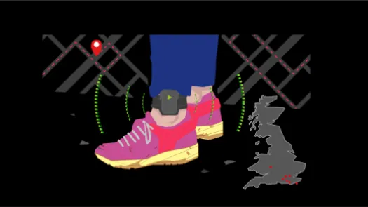
The tag itself is usually attached to the ankle, using a reinforced band.
Traditional radio-frequency tags rely on two different elements, a base station usually located in the individual’s house and connected to the network and a tag attached to the individual. They are typically used to enforce curfew conditions, such as that an individual remain at home from 7pm to 7am.
The base station polls the tag occasionally over a specific radio band to detect if it is within range. If the tag fails to report (or the signal is below a theshold) then it will raise an alert, and a number of alerts over a timeframe will prompt the tagging authority’s control center to phone the tag wearer on their landline. If this fails, the control centre may ask law enforcement to visit the address and ascertain if the wearer has absconded.
It’s worth noting that some Radio Frequency tags dedicated to home arrest pack additional features such as the BI HomeGuard 2020 which includes a GPS chip in the base unit to report the location of the base unit itself.
A GPS ankle tag only consists of the tag attached to the individual. There is no base station. It features a GPS (Global Positioning System) navigation chip in the tag. This communicates directly with a control centre through a mobile network, whether General Packet Radio Service (GPRS) or 4G. The tag also has a SIM card (or equivalent) to authenticate it to the network, and is similar to a smartphone (although without the microphone, camera or speaker.)
The House of Commons Committee of Public Accounts report in 2018 stated that “All GPS equipment tracks offenders movements using GPS signals backed up by mobile signals when GPS is unavailable or weak.”
While GPS location is accurate to about ten metres, with larger errors in urban canyons and other locations where only a few satellites are visible, geolocation based on the mobile phone network depends on the density of mobile base stations. The density of mobile base stations can vary from a hundred meters in town centres to several kilometers in the open countryside.
Much like a smartphone with location services enabled, GPS ankle tags can report the wearer’s location to the tagging authority’s system every minute or so. However the frequency with which this location history is uploaded to the control centre depends on the product, and how it is configured for a particular wearer.
For example, the ‘Attenti One Piece Tracking Device’ states in its manual that in Active Mode “The standard 1 Piece call-in interval is once every hour while in compliance” while in Passive Mode “the standard 1 Piece call-in interval is once every six hours.”
It’s worth noting that ankle bracelet can embed additional sensors or features for specific purposes. For example Jimi IoT, a China based company, offers an ankle bracelet with temperature sensors, enabling these bracelets to “send out abnormal temperature alert designed for quarantined offenders” in the context of the Covid 19 pandemic.
To summarise, while radio-frequency tags tell the tagging authority whether the tag wearer is observing a curfew, GPS tags provide the authority with a complete location history - a log of where the tag was minute-by-minute of every day. This information can be accessed directly by control-centre personnel, by probation services and by the police, and also monitored by software. A tag wearer can be prohibited from certain areas, such as a football ground or a school, and an alarm raised if the wearer goes there.
Electronic monitoring tags are usually provided by a private firm under a service contract with the relevant public body. The more modern GPS ankle bracelets are usually more expensive than the simpler radio-frequency tags.
Costs include equipment, service provision (interfaces databases and associated program), maintenance and support. A 2012 BBC article stated that ankle monitoring was much more costly in the UK than in the US (£13.14 per monitored day in England and Wales, while the equivalent in the US was £1.22). Around this time, the UK had two curfew tag providers, both of which were accused of defrauding the Ministry of Justice and were replaced by a third firm.
During a recent pilot in 2019 by the UK Minitry of Justice, the costs were estimated at £55 per wearer per day.
In the UK companies contracting with the Ministry of Justice for these services now include:
Anyone who has used a GPS-based smartphone app such as Google Maps will have seen something very similar to how GPS tags work; the app will record your location on the Earth’s surface, from which it can also work out your direction of travel and speed.
This geolocation is done entirely on the recipient device, as the GPS signals are one-way from the GPS satellites to the GPS location chip. There is no return signal. This means that the actual tracking implementation is up to the tag technology, rather than the satellite technology.
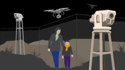
While the two types of ankle bracelet can serve specific function (e.g.: ensuring that a tagged individual does not leave home at certain times in the case of radio-frequency ankle tag or preventing access to a forbidden area via geofencing with a GPS bracelet), there can be a temptation to rely on GPS ankle tags for more given the level of detail they can provide. The location histories of known offenders have been used to investigate crimes; the police can search for any offenders who were near the scene. The real-time location monitoring is then used by police to find and arrest the tag wearer.
This temptation must be balanced against the invasiveness of such tracking. Not unlike a smartphone with location services enabled, GPS ankle tags provide a deep insight into one’s life and can reveal intimate details to the person analysing the data. This type of constant surveillance has been reported to negatively impact tag wearers leading to feelings of increased anxiety. In addition individuals might not want to spend time with a friend who is wearing a GPS tag. Therefore it risks having a strong chilling effect.
The London Mayor’s Office for Policing (MOPAC) in the UK, who use the Buddi tag, state in their review of GPS Tagging in July 2018 that Offender Managers used the data to:
“find out new information about the tag wearer’s lifestye” and to “challenge the tag wearer about his or her behaviour.”
The MOPAC pilot using GPS location tags and associated software package enabled Offender Managers to receive bespoke email notifications “highlighting key locations visited by the offender in real time, heat maps" and “Top 5 locations of the week” reports, so that "patterns of behaviour associated with risk can be uncovered, explored and challenged.”
In a 2019 document, the Essex Police in the UK, stated in a review of electronic moniotoring using GPS that:
In a UK Ministry of Justice evaluation in 2019 it states under perceived benefits for offender management that GPS tags “enabled responsible officers to access historical data about a wearer’s lifestyle and how they spent their time, which was not available previously.” The report also noted that some police and probation officers wanted easy access to the data i.e. rather than going via the third party contractor, to:
“help build a more comprehensive picture of wearers’ day-to-day lives, giving, for example, an indication of their willingness to engage in positive rehabilitative activities where relevant. Likewise, it could alert officers to any issues they might need to discuss with wearers – for example if data showed wearers were frequenting areas where acquaintances involved in previous criminal behaviour lived.”
In relation to migration, the UK Home Office have stated in their updated guidance on Immigration bail that:
“trail data will be held by the EM supplier but may be accessed by the Home Office where one or more of the following applies and where proportionate and justified in the circumstances in accordance with data protection law:
…
- where it may be relevant to a claim by the individual under Article 8 ECHR
- to be shared with law enforcement agencies where they make a legitimate and specific request for access to that data
- anonymised data may be used to understand the impact of EM and the behaviours of those on EM to continuously improve the service and to informimmigration policy, in accordance with data protection law”
The chips in tags are usually accurate to around ten meters, but require an open view of the sky and are affected by surroundings. Smartphone users will probably have experienced much larger errors in cities; if the signal from one or more satellites bounces off a tall building, this can give rise to an error of 100m or more. Larger errors can also arise where the view of the sky is restricted so that only a few satellites are visible. The vendors of monitoring devices and services may not always be aware of these limitations, and may make ambitious claims about the accuracy of the location traces they provide to an authority.
The risks associated with tracking do not just occur when the data is collected, but continue as long as it is stored - in particular once it has been linked to an individual. Thus there are concerns about how such data such as these could be repurposed by government agencies.
The 2019 MOPAC report indicates a desire to use tag data for police to undertake crime mapping: “Under the POP pilot, allocated probation Offender Managers (OMs) can access and monitor location data for their cases. Where the tag wearer is the subject of an SSO the police can also undertake crime mapping, matching location data with crime data where it is relevant and justified for the detection of crime.”
In a 2016 Report on Electronic Monitoring, academics at the University of Leeds stated that Police forces are routinely analysing tracking data from GPS location tags “to investigate crime and to gain intelligence and linking it with CCTV and ANPR records.”
More recently, the 2020 UK Home Office Data Protection Impact Assessment relating to the roll out of GPS tags for immigration purposes, elaborates on the intention, referred to above, to use location data in decision making on asylum and immigration cases.
“Home Office staff may request access to GPS trail data for a specified period (not limited) and review that data in the event of either of the following occurances:-
…
Article 8 Representations / Further Submissions
In the event of the receipt of Article 8 representations or further submissions from the individual, authorised Home Office staff dealing with those submissions may request access to the full trail data to support or rebut the claims. This will hopefully negate the need to request ‘substantiating’ evidence from third party’s which can cause unnecessary delays in considering the claims.”
The Home Office DPIA confirms the intention for the number of tag wearers to rise from 280 to 4500 and that the purpose is daily 24/7 monitoring of individuals subject to immigration control.
The use of GPS tags raise considerable issues, both technical, legal and in relation to the quality of evidence from a forensic perspective. We caution against those rushing to deploy this technology.
Further, through our investigative work and the work of our partners around the world, PI has identified a number of issues common to public-private partnerships that involve surveillance technology and/or the mass processing of data. Given that the use of GPS tagging involves contracting with private companies, we highlight corresponding safeguards that we recommend for implementation by public authorities and companies who intend to enter into such partnerships.